B&W Studies

Joining in the current black and white processing craze!

Will start with something subtle. Pre-storm sky from May of 1997.

Spend many hours at the Amarillo Weather Office with Brian Curran (then Warren Faidley showed up and we left).  This in looking east from US 207, down in the beautiful Palo Duro Canyon.

Cirrus uncinus over early cu (a 50 kt. mid level jetmax was approaching from the SW).  Taken with one of my old Pentax ME Super (I had two!) and processed in Lightroom 4.3.

Ended up chasing the convection that later developed just off the Caprock, with most of the time spent between Turkey and Matador.

F1000002web crop
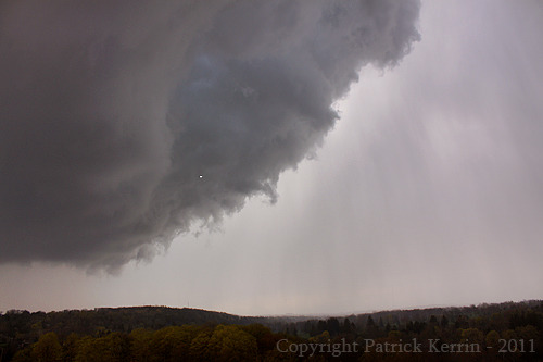
Next up is this image from 24 May, 1996, N of Muleshoe, Texas.

Started out at Amarillo and initially chased north east near Pampa but blew that off and picked up the cells in the western panhandle.  I really like how the twilight works with the updraft in the grey scale version of this image:

F1000034web crop
Best cell was later, after dark, just south of Amarillo – a beautiful TOR warned laminar updraft occasionally illuminated by lightning (unfortunately couldn’t get a decent shot)!

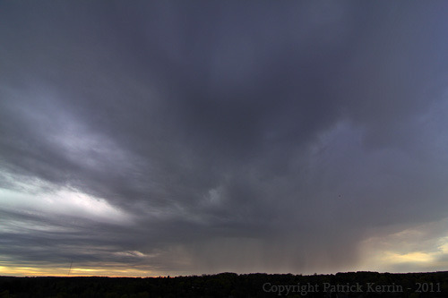
Moving forward to 30 May, 2012, west of Childress, Texas.  Maturing supercell that would later produce giant hail (this small cluster of supercells produced official hail reports up to 4.5 inches).  We (John Moore, Linda Kitchen, and Kathy Velaquez) got “Delormed” (navigational snafu where map fails to let us know that the road we are on will turn to dirt which will be unnavigable once wet).

We found a safe place to park the vehicles (large metal-roofed car port) in the middle of nowhere and rode out the barrage of hailstones (up to roughly just bigger than baseballs) with Brady Kendrick and Jay McCoy.

This will be remembered fondly as it was the last I would chase with Linda, who passed away this year.

IMG_3250web cropHere is the cold hard reality of Lake Huron in the winter.  From Grand Bend, Ontario, March 2008:

Grand Bend-Lake Huron 3-24-2008web crop-2
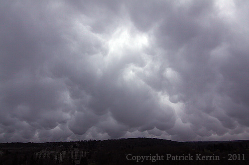
Mammatus over Old Faithful, 4 June, 2006.

IMG_1988web cropRoll the clock back to May 1992 – image taken with the Pentax ME Super and a 150mm zoom, leaning over the edge of the Royal Gorge bridge (955 feet over the Arkansas River), near Cañon City, Colorado.

Railfans may be able to identify the locomotive type (a little poking around suggests it is a ‘Denver & Rio Grande Railway’ freight).

F1000018web cropKnuckled-anvil Supercell, developing just outside Amarillo, Texas, May, 1996.

The chase is on!

F1000019web cropBack further to late May of 1994, a big ol’ Yucca plant near the banks of the Pecos River, off TX 290, a few miles SE of Sheffield, Texas.

I really like how the grey scale gives this a ‘Texas in 1880’ vibe!

I just love the vistas and landscapes of SW Texas!

F1000023web crop-2
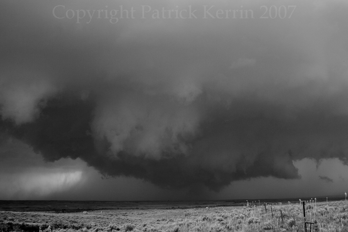
23 May, 2007, taken from a couple of hundred meters WSW of the intersection of TX 70 and FR 283 in Roberts, County, Texas (about 21 miles NW of Miami, Texas).

Although I couldn’t see a ‘clear-cut’ circulation on the ground, this is in Storm Data as a EF0 tornado that tracked briefly about two miles west of the intersection (reported by a ‘Trained Spotter’ – I do not know who made the report).

IMG_4488web crop
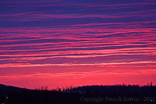
Aftermath of a relatively minor Ice Storm with little Sun Dog, NW of London, Ontario.  Best guess is this is from the late 1990’s or early 2000’s.

F1000036web crop-2

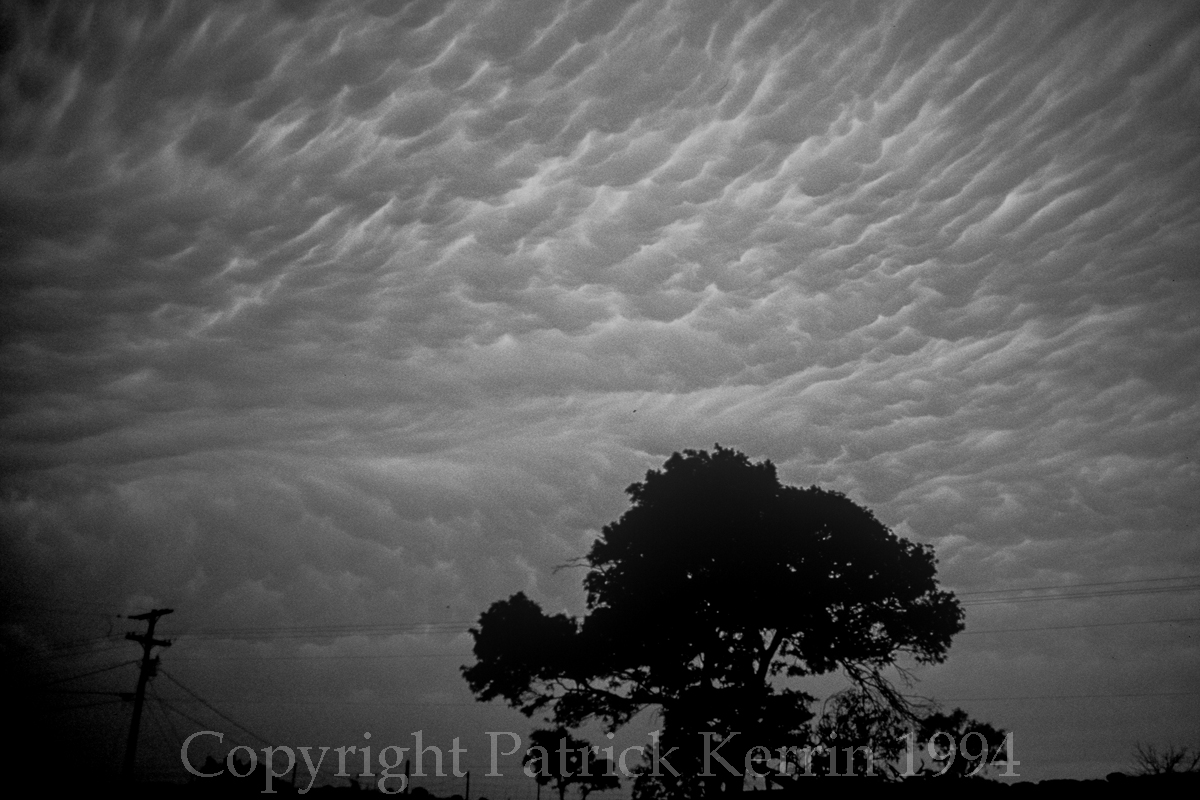
Quilted Sky full of Mammatus. 29 May, 1994, near Goldthwaite, Texas (pretty much smack-dab in the center of the state!).

Started out in Austin, made a BAD forecast, and could only recover and get close to the storms at dark (and called off the chase because of the heavy rain and the fact there were just too many cells).

It was, as any bust is, a valuable learning experience.

F1000008web cropArches National Park, May, 1992.

F1000003web crop 2
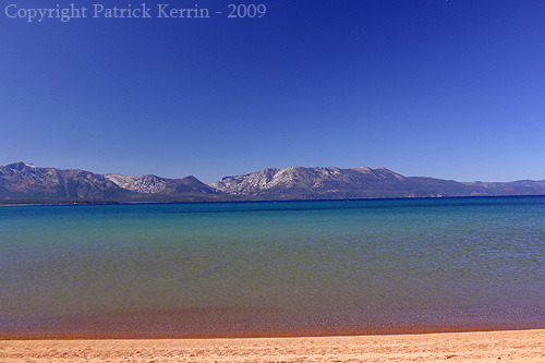
Lake Tahoe stack of plates.

Altocumulus Lenticularis taken from the beach out in front of the Hyatt Resort in Incline Valley, Nevada (NE corer of Lake Tahoe), October 2009.

IMG_2298web crop 2


September Whale’s Mouth – London, Ontario – 5 September, 2014

Probably the last good chance for decent storms in 2014.  High instability,  moist boundary layer, and a modified/remnant EML at mid levels were the PROS – one big CON:  Upper level flow lagged off to the NW and meant that precip would fall into adjacent updrafts and morphology would quickly shift to linear/outflow dominant mode.

Still meant there would be some decent shelf related structure and was able to document a nice Whale’s Mouth and precip core at London, Ontario:

IMG_1217web crop Continue reading

23 May 2012 – E Colorado Chase

Preliminary summary to get the images out there – will update with more details as time permits,  Chased with John and Kathy Valequez / Linda Kitchen (the ORIGINAL Twister Sisters).

Chased E CO – met up with new appointed Professor of Meteorology Victor Ginsini (congrats Victor) and two of his friends from Georgia.

Dewpoint was 39F at this time this pic was taken – pretty little cell none-the-less!

Again, click all images for a larger view!

Later on got on the tail-end cell that came up from Pueblo, CO.  We were about 15 N of Lamar and the Dewpoint was up to 45!!

Was able to catch one images of lightning on this picturesque supercell!

Ate at the Cow Palace after the chase.

20 May, 2012 Annular Solar Eclipse

Second chase season in a row that chase partner John Moore and I included a non-chase, but still scientific endeavor on the way out to chase after leaving Phoenix!

Back in 2009, we stopped and checked out the really cool Very Large Array radio telescope in central New Mexico. This year, it was a West Texas/Eastern New Mexico take on the annular solar eclipse!

Original target was Bledsoe, Texas, but as we stair-steped Southeast from Albuquerque, we noticed a pancake cumulus field developing along and even west of Texas/New Mexico border.  As we drove into Texas, we became concerned that this could cause a serious impediment to viewing the eclipse, and even potentially block it out.

We then recalculated and planned to head back west into New Mexico. John found the exact point on the road we took south from Portales that was on the center-line of anularity, and programed that into the GPS. As we headed back into New Mexico, there was some dissipation of the cumulus, but we realized we had made the correct move, as we could see the far west edge of the cu field.

We pulled off on the dirt road that was right on the center-line and started the set up the cameras.  We had arrived after the partial phase and started shooting.  Here is an early-on example that also captures a couple of sunspots (click on images for larger view):

At this point (and right through the annular phase) the sun was quite bright, and had we had to use special filters I purchased for this trip (and will hopefully come in handy for future eclipses).

Our calculations were perfect, and we achieved the main goal of being able to photograph perfect symmetrical annularity!!!

As the sun sank lower in the sky it finally became possible to photograph without the filters – we were now capturing all the colors of a Llano Estacado sunset!!

John particularly liked this one, as he felt it look like a shark’s tooth, I was inclined to think it was more like a shark’s fin, but nonetheless it was a great way to end a great eclipse!

The video didn’t turn out so well (too bright, causing severe flaring), but who cares I got the still shots. Will have more to add over the next few days and weeks to fill in some gaps.

Sunspot 1471 – Test shots for 20/21 May Annular Eclipse

Took some test shots on the Cinco de Mayo sunset (in preparation for the possibilty of being able to document the 20/21 May Annular Solar Eclipse) and it looks like I caught what spaceweather.com is calling sunspot 1471 (sunspots move left-to-right across the face of the sun) just before the sun dropped below some clouds that were just above the horizon.  Click on image for larger view:

This was just a quick test, hand held at 1/160th of a second.  Lens was the Canon 70-200 mm F4 IS with auto-focus OFF, and a single Kenko Pro 300 1.4X teleconverters and two Kenco MC4 2.0 telconverters on the 5DMll.  Effective focal length is 1120 mm.  Image stablisation ON.  I had stopped down to I think F5.0, but with all those teleconverters it was like F200!  8^)

If we get to shoot the event (and I am hearing chatter that other chasers are looking at this photo op, if there are no chasable storms that day) I will be on the tripod and will hopefully have the imaging technique even further under my belt.  And there will be bigger glass (more on that later)!  Stay tuned…

2012 Weather/Chase Season – Mid-March Lightning!

Tags

, ,

Got to test my new 35mm prime on the Canon 5D Mark II on a storm!  There were a couple waning cells that approached London, Ontario after dark from the same cluster of storms that included the Supercell that produced a (possibly) Strong tornado about 10 miles west of Detroit.

The cell was spitting out anvil crawlers intermittently (i.e. I noticed ONE) and waited about five minutes and didn’t see another and gave up.  The activity then increased to maybe one every three minutes, but the cell has moved E and the origin of the bolts was now too far east to see from the Weather Perch (TM) …

…but I got one shot  that captured a crawler’s tail (click on image for larger view):

So a very satisfying start to the actual observing and documenting convection in 2012!

Will follow-up on this lens (and the other one being changed-out when all is settled)…

2012 Weather/Chase Season – Birds In Transit

Tags

,

Well preparations for this years chase expedition continue – the lens change-outs are almost complete (will discuss in further detail when everything is done/resolved), but here are some test shots to share…

In preparation for the possible opportunity to document the near/at sunset Annular Solar Eclipse in W Texas/E NM on 20 May, 2012 (and the even-more-rare 5 June, 2012 Transit of Venus!), I picked up a couple of 2x MC4 Kenko Teleconverters (at half price!) to test with the Canon EF 70-200 IS F4.

I was willing to even try these with the Kenko Pro 300 1.4x teleconverter I picked up three years ago (that produce no appreciable image quality degradation with the 70-200)!

So yes I was expecting loss of image quality, but will that matter when dealing the a sun so close to the horizon that atmospheric effects are already maximized…

This attempt (hand-held!!!) with 200 x 2 x 2 x1.4 – 1120 mm of reach allowed me to capture these geese passing in front of the sun!!  Also note that this is pretty much right at the first contact with the local horizon (note the distant tree-tops) and includes a contrail.

It also looks like there may be a couple of sunspots visible (I know sunspot #1429 was big around this time, but I am not experienced enough at sun observing  to say for sure) – click on image for larger version:

So I tried – so far I am happy!  I will continue with various combinations  of the TC’s to find a sweet spot of image quality and magnification – that again may be dependent on the given state of the troposphere!

This combination (also hand-held!) also seems to hold some hope for some interesting compressed ‘skyscapes’, like this example from the same series:  a mix of cirrus, old contrails that have evolved into cirrus, big middle-aged contrails, and one new contrail being created:

It seems that, at least with high and distant clouds, the image quality loss from all that extra glass, is at least, not unpleasant.

Will look forward to exploring more (and with the tripod)!!

The Meteorology behind the 24 August, 2011, SW Ontario Tornadic Event

Tags

The 24 August, 2011 event shared both similarities and differences with the 21 August, 2011 event.

Both were tornadic, and both had similar synoptic scale upper-level patterns. Some of the differences included the mesoscale surface pattern and the reactions of the general public, both before, during and after the events.

This time we take a proper top-down look at the setup.

On the morning of the event there is again an approaching upper level jet max, rotating around a large, long wave trough:

At 250mb:

300mbgif

Continue reading

The Meteorology behind the 21 August, 2011, Goderich, ON Tornado

Tags

Many of the public in Goderich were surprised by the occurrence of a Strong Tornado (i.e. F3 damage), stating they thought it was just another thunderstorm (as opposed to the reflection often given by the public in high-dewpoint events: “It felt like there was going to be a bad storm”).  Many chasers and meteorologists were also surprised with the evolution of events.

Environment Canada did a good job – a warning was out with about ten minutes lead time, which is sufficient for members of the public to take action and responsibility for their safety, if they received the warning.  EC also had a Severe Weather Watch out that did mention a tornado was possible – but did not have a Tornado Watch in effect.

This was a day where the possibility of a strong tornado was evident, if you looked in the right places.  If you looked in the wrong places you could be easily have missed it coming.

I, unfortunately had other things on my plate and did not look farther than SPC Tornado Probability guidance:

Day1probotlk_2000_torn

Continue reading

2011 Weather – 5/10/2011 Anatomy of an even weaker Elevated Convective event!

Tags

Wow, it’s May, and I feel compelled to talk about the weather! Go figure!!  Especially about events I have witnessed. In these days of hyper-extreme TV “StormChasers” bent on getting closer in/inside vorticies, as if ‘if your face’ is all that matters (sorry, its NOT), I am happy to take some pride in enjoying analyzing and writing up on a weak – but photogenic – convective event.

As with normal weekday life these days I arrived home situationally unaware.  Plus this was band rehearsal night. so there was no time to indulge in an array of weather data (and I am happy to report we nailed that night’s attempt at the full album version of The Doors’ “Light My Fire” – we have such a good keyboard player!). So shortly before I need to leave I hear…thunder! 

Got out to the Wx-Perch to observe VERY high based convection/precip to my NW.  Saw one CG pop out from the side edge of the precip core and got off a couple of wide angle images before leaving to practice. Here is an ultra-wide image of the storm (new feature – click on image for larger version) – the main precip core is roughly eleven miles to my NW:

Media_httpcanadiantex_bnojp

Continue reading

2011 Weather – Anatomy of a Weak Hailstorm / GIF and GR Level 3 Image Workflow

Tags

Had no chance to see any weather data at all through the day on Friday , so when I returned home I was situationally unaware.   I don’t like that, and especially in May, and especially when I hear thunder as soon as I walk in the door!  A quick dash to the window revealed a developing cell just to the west – the first for the new place and the WX-Perch (TM).

Had a quasi-conical, but scuddy non-rotating lowering just below a linear updraft base, so it was time to grab the camera!  By the time I got back the lowering was gone and I was treated to a nice sculpted vault behind the leading shelf cloud – so at least I did get a nice structure shot out of what was going to be a very fleeting ‘low-end’ (but pretty!) event.

Media_httpcanadiantex_saced

Continue reading

Concert Photography – Skid Row

Tags

From the Thursday of the 2008 Rock the Park Festival in Harris Park, downtown London, Ontaro. Skid row followed Metal Queen Lee Arron (pics to follow), and ahead of Joan Jett and the Blackhearts, and headliners Sammy Hagar and the Waboritas (pics to also follow for both).

Good performance, may have been hampered in that they did not have lead guitarist Dave Sabo (Keri Kelly filling in) and it was not the same as having original singer Sebasian Bach. Event is notable for a couple of consecutive images I took – the first capturing guitarist Scotti Hill in mid-head bang, with hair speed-blur suspended between weightlessness and the descending head bang.

Such an image has to be taken the proper milliseconds after the downward head-bang is initiated, taking into account shutter lag and certain other optical adjustments based on dewpoint and solar refractive factor… OK, I am BS-ing, it was just pure LUCK!!

Media_httpcanadiantex_kjcae

The VERY next shot has vocalist Johnny Solinger acknowledging the shot I just got – “Dude, you got that one” (again BS-ing)

Media_httpcanadiantex_mftpl

Though that was actually the next shot I took.  Lotsa fun!!! .

General Weather Images – Sunset New Year’s Day 2011!

Tags

,

Captured this fleeting image of the 2011 New Year’s Day sunset at London, Ontario, with the setting sun illuminating the post-frontal altocumulus!

Media_httpcanadiantex_qdjjo

Hopefully a harbinger of many more weather image to come in 2011!

Taken with the 50D and 70-200 IS F4 with 1.4x extender: 257mm (411mm full frame equivalent), ISO 400, 1/50 second handheld.

No time to set up the remote shutter-release – a tripod-ed shot would produce a better image, but the IS allowed me to capture a decent image of the fleeting scene.


.

Wedding & Honeymoon: Lake Tahoe

Tags

Media_httpcanadiantex_qfdcz

The plan for the weekend was to just kick back, relax, and enjoy beautiful Lake Tahoe.  After the almost storm-chase intensity of seeing a good part of four major National Parks over the last five days we were looking forward to the down time.  Sit on the beach, sip wine, read! Lake Tahoe is at quite a high elevation – 6225 feet above sea level – and is fairly large: 12 miles by 22 miles. It is also quite deep at 1,645 feet! 

Continue reading

Wedding & Honeymoon: Yosemite National Park – Part III: More Icons & Tuolumne

Tags

As I mentioned in a previous post, I had done a fair bit of planning so that we could get the most out the limited time we had in each of the Parks. A great help for anyone interested in photographing, or even just visiting Yosemite, is “The Photographers Guide to Yosemite”, by Michael Frye, and is currently available at Amazon or at The Ansel Adams Gallery (which is located in Yosemite) for a reasonable price.  T

his book is so highly regarded that when it was out of stock for a while before the wedding it was selling in some places for twenty times the sticker price! It became available again (whew!) about a month before we left and got it through the Gallery at the normal price (and it turned out to be an autographed copy!)! The book suggests all sorts of ‘secret’, or at least ‘off the beaten track’, locations for photo ops that would otherwise go unnoticed.  We chose Cathedral Beach along the Merced River for a morning El Capitan study.

Michelle got very creative and decided to hang over a big log to get the camera right down to the water level to maximize the mirroring effect of the calm water!

Media_httpcanadiantex_cggle

Continue reading

Venus and Mars (and Saturn) are Alright Tonight!

Tags

,

All three planets in a ‘V’ shape (and pretty dern close to being an isosceles triangle!), with Venus the brightest at the bottom of the ‘V’, reddish Mars forming the upper-left part of the ‘V’ (just on the edge of a high cloud!), and Saturn as the upper-right part of the ‘V’:

Media_httpcanadiantex_baish

γ Vir of the constellation Virgo is upper left of the image.

Taken on the 70-200 f4.0 IS at 98 mm (100 ISO for 20 seconds).  Its rare to have these planets all bunched up in about 8 degrees of sky!  And the Crescent Moon joins the party on Thursday night, just in time for the Perseid Meteor Shower!

Wedding & Honeymoon: Sequioa National Park

Tags

Media_httpcanadiantex_emmja

Started the day in Visalia, CA after the long drive the night before from DVNP.  Wow, California actually has freeways, and is, in some places, densely populated. Like Visalia – it actually has over a hundred thousand people! I jest, but that is how it kinda felt after seeing so much of ’empty’ California, and then getting back to something even slightly urban.  Continue reading